MONDAY, JULY 21, 2014:

I would travel 257 miles today visiting Glacier and Waterton parks.


All of the images below are thumbnails and can be clicked on for a larger image.

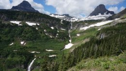
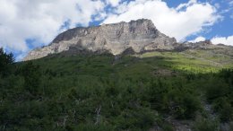
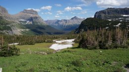
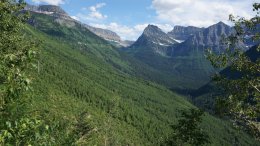
Montana's Glacier National Park is located on the Canada-United States border.
Glacier National Park Glacier National Park Glacier National Park

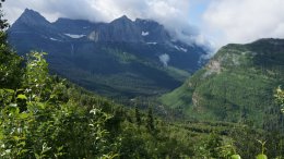
The park encompasses over 1 million acres and includes parts of two mountain ranges,
over 130 named lakes, more than 1,000 different species of plants, and hundreds of species
of animals. This vast pristine ecosystem is the centerpiece of what has been referred to as the
"Crown of the Continent Ecosystem", a region of protected land encompassing 16,000 square miles.
Glacier National Park Glacier National Park Glacier National Park

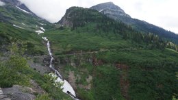
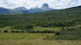
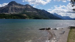
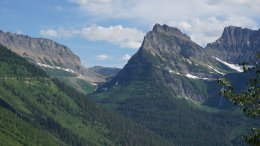
After traveling all the way through the park in the morning I ventured into
Canada for a couple of hours. The picture below is looking back on
Glacier National Park from Alberta, Canada.
Looking back on Glacier National Park

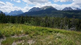
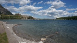
Waterton Lakes National Park is a national park located in the southwest corner
of Alberta, Canada, and borders Glacier National Park in Montana.
Waterton was Canada's fourth national park and named after Waterton Lake.
The park contains 195 square miles of rugged mountains and wilderness.
Canada's Waterton Lakes National Park Canada's Waterton Lakes National Park Canada's Waterton Lakes National Park

The video below is 20 minutes long of Waterton Lakes National Park.

After my short side trip to Canada I returned to Kalispell
using the exact same route in which I had come.
Glacier National Park Glacier National Park Glacier National Park

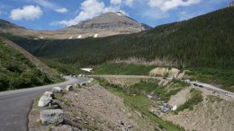
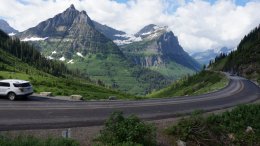
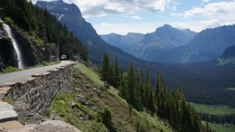
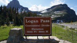
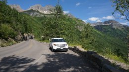
When I crossed over Logan's Pass earlier in the day there was no place
to park. I was able to find a parking space during my afternoon visit.
Logan Pass (elevation 6,646 feet) is located along the Continental Divide.
It is the highest point on the Going-to-the-Sun Road.
Glacier National Park Glacier National Park Glacier National Park

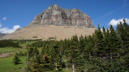
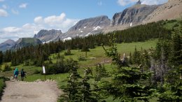
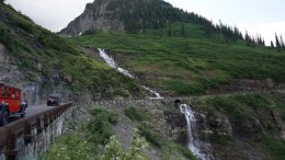
The most amazing highlight of Glacier National Park is the drive on the
Going-to-the-Sun Road. This engineering marvel spans 50 miles through
the park's wild interior, winding around mountainsides and treating
visitors to some of the best sights in northwest Montana.
Glacier National Park Glacier National Park Glacier National Park

The video below is 53 minutes long of Glacier National Park.

MY DAILY EMAIL SENT ON JULY 21, 2014
Hello again folks,

I had a great day today. After breakfast at the hotel I headed out at about 7:30 this morning. It was about a 45 minute drive to the entrance of Glacier National Park. In Glacier I traveled on the "Going to the Sun" highway. The first 20 or so miles in the park are mostly forest as you ride beside Lake McDonald and later the river. But after about the first 20 miles the road gets spectacular.


It was a beautiful day. A few low clouds this morning but it became a mostly sunny day. In the picture below you can see one of the Glacier Park touring cars passing in front of Bird Woman Falls.


The scenery is breathtaking. The picture below is looking down on where I had come from.


The picture below is the Weeping Wall. If that motor cycle were in the other lane he would have gotten very wet.


Below is looking down on one of the many switchbacks on the highway. I was still climbing up the mountain at this point.


That line just below the snow in the picture below is the road going up the side of the mountain. Barbara, this looks like a good place for your next adventure.


Still climbing in the picture below but getting near the top. That is Logan Pass you see above.


There was not a parking space to be found anywhere at Logan Pass so I had to skip it and head down the other side. Below is looking up at Logan Pass from the other side. Also a lot of pretty waterfalls in the picture.


A waterfall beside one of the tunnels is pictured below. Shortly after that picture was taken the road was under construction until almost the end of the park. It was not possible to take pictures while dodging bull dozers.


While heading north on the other side of the park there was a large herd of cows standing in the middle of the road.


Pictured below is the Canadian border and the entrance to Waterton-Glacier Peace Park.


So this was an international trip. Below is a picture looking down on the park.


That is the Prince of Wales Hotel perched above the lake and looking down on the town site. I ate my lunch sitting here in front of the lake.


I really wanted to spend more time here. But it was 3:00 and I had to drive all the way back to Kalispell. So I headed back to Kalispell retracing the exact route in which I came. I spent about 90 minutes in Canada. Driving in the opposite direction gives you a whole new perspective on what you have already seen. I saw lots of scenic points I didn't notice the first time heading the other direction. Below is the back side of Glacier National Park.


Unfortunately I had to go through the road construction again. Below is another hairpin curve climbing back up the Going to the Sun Highway in Glacier National Park.


And the nice thing about doing things twice, I did find a place to park at Logan Pass this time.


Below is looking east from Logan Pass.


I walked along the Highline Trail for a short while. As usual my feet wouldn't let me go very far, but I did get a look at a couple scenic vistas.


You could really smell the pine along the trail.


Now it was time to go back down the other side of Logan Pass. The sun was in better position for some views than it was hours earlier when I was here before.


And in my final picture below you can see another one of the touring cars heading down the mountain.


I got back to Kalispell at 7:30. It took less than half the time to get back since I made considerably less stops. A stormy day is predicted along my path for tomorrows journey. So I am hoping it doesn't interrupt my planned activities.

Until tomorrow,

Tim
Click on email photos for the large full-size photograph.


Click on the arrow above to continue to tomorrows adventures!

TIM'S HOME PAGE SITE INDEX
AreasDescription# of Pages
About MeCurrent Picture of me and my home.
Information about myself.
2
BiographyPictorial biography of myself.
Pictures range from birth to adulthood.
4
Family FilePictures of my family
and a little information about them.
12
Local SpotlightPictures, Links, and Information for
Indianapolis, Richmond, Plainfield,
and Mooresville, Indiana.
5
Tim's TravelsPictures, videos and travelogs from
my travels around the world.
409
  Vacation Videos   Over 1500 videos from
my travels around the world.
1
NOTICE: THIS WEB SITE WILL BE PERMANENTLY CLOSED ON JUNE 1, 2024